Situated in the West Limerick uplands, Abbeyfeale is the westernmost town in the county and is around 900 years old. Mainistir na Féile, meaning “Abbey of the Feale” is named after the former Cistercian monastery which was located adjacent to the current town square and is a historical market town. The Abbey has since all but disappeared, and the only identifiable remnants are those used in the construction of the Roman Catholic Church in 1847.
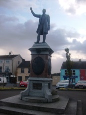
The main feature in Abbeyfeale’s Square is a statue of Father William Casey. Originally from Kilbehany in East Limerick, Fr. Casey was Abbeyfeale’s parish priest from 1883 to 1907 and was an advocate of tenant’s farmers rights.
Abbeyfeale also has a number of buildings of important architectural merit. Pat McAuliffe lived and worked in Listowel, Co. Kerry from 1846 to 1921. In a career as a builder he applied exterior plaster, or stucco, upon shopfronts and townhouse facades in the region. From the 1870s onwards he began to develop an ambitious and often exuberant style, using a broad range of elements culled from the vocabulary of classical architecture and ornament while exploring an eclectic mix of art nouveau, Celtic and Byzantine influences. Some of the finest examples of his work can be found in Abbeyfeale.
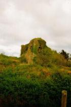
Like much of West Limerick, Abbeyfeale also has links with the Earls of Desmond and the Geraldine Tradition. The Geraldine Portrinard Castle (or Purt Castle) is situated about 2.5 km northwest of the town, on the north bank of the Feale along the increasingly popular Great Southern Trail Walking route, an unique 85km stretch of countryside in West Limerick/North Kerry. It is the route taken by the Limerick – Tralee railway line, which opened in 1867/1880 and closed in 1975/1977. http://www.southerntrail.net/
Abbeyfeale History
1116 A Cistercian Order founded a monastery/abbey situated in the today’s town square1.
1188 The above abbey came under the jurisdiction of Monasteranenagh Abbey near Croom. Part of this site was used as a parish church until 1846, when a new Catholic church was built on Church Street during the reign of parish priest Daniel Lyddy1.
1846 Catholic church built on Church Street, when Daniel Lyddy was parish priest.
The Convent of Mercy built when Michael Coghlan was parish priest from 1856 to 18831.
From 1823 to 1829 a Public Works program provided employment resulting in new roads built from Newcastle West to Abbeyfeale to Castleisland and Abbeyfeale to Newmarket, Co. Cork1.
In 1822 There was only one slated house in the town and this was used as an army barracks. On 18 February 1822 insurgents attacked this barracks and demolished the building1.
1831 Richard Griffith, Public Works engineer, noted that a number of new houses were built and new shops were established since his previous visit in 18221.
1836 Abbeyfeale to Glin road was completed1.
1840 Ordance Survey listed Abbeyfeale Parish landlords, with all but one were absentee landlords1.
Abbeyfeale East & Abbeyfeale West owned by Richard Ellis of Dublin
Kilconlea Lower & Kilconlea Upper owned by Conyngham Ellis of Dublin
Knockbrack & Knocknasna owned by Lord Southwell of England
Port owned by William Folk of London
Dromtrasna North & Dromtrasna South owned by Lord Guillamore, Bruff
Dromtasna Collins owned by De Courcy O’Grady of Kilballyowen
Ballaghbehy North, Ballaghbehy South & Dromtrasna Hartnett owned by Richard Herbert Fitzgerald of Limerick; Ballaghbehy owned by Edmond O’Grady, M.P., Dublin
Caher Connell & Crag owned by Ottaval Hayes of Cork
Caher Lane owned by Patrick Hayes of Abbeyfeale
Caher Hayes owned by Colonel Keating
In August 1848 Limerick to Tralee mail car was attacked and robbed near Abbeyfeale by “400 wretched looking creatures armed with old firearms and sticks” as this was the result of a number of years of famine and hunger1.
Pre-independence period Glenashrone House, now gone was situated slightly east of present day Ellisa Wood housing estate on the Killarney Road. This was the estate home of landlord Richard Ellis.
1800’s House
Dromtrasna Harnett – Crag House, Mill Farm, Wellesley Farm and Inch Cottage still exists
Moanavilla House ??
Dromtrasna Collins – Bogmount House
Knockbrack – Mountain View House, Bridgemount House,
Knocknasna – Fealeview Lodge over river Oolagh, Acloon House home of Fitzgerald family,
Schools
1867 Springmount Primary School in Ballaghbehy North was built and closed in the late ????.
Meenkilly Primary School
1898 Feale View Primary School founded1.
Dromtrasna Primary School.
Knocknasna Primary School.
The parish of Abbeyfeale is served by the rivers, the Oolagh (the proud river) and the Allaghaun while the Feale marks its southern and western boundary.
Bridges
Drehidnacarriga Bridge (Caher Lane)
Caherlane Bridge known locally as Weara Bridge
Meenahala Bridge
Gourbourne Bridge built in 1827 by Richard Griffith, Board of Works engineer
Wellesley Bridge or Feale bridge
White Bridge over Oolagh river at Knockbrack
Crataloe Bridge
Rathoran Bridge
War of Independence
19 September 1920 Constables O’Mahoney & O’Donoghue shot in an ambush on outskirts of Abbeyfeale by West Limerick Flying Column of the IRA1.
21 September 1920 Patrick Hartnett & Jeremiah Healy shot by Constable Thomas Huckerby1.
5 June 1921 Robert Jolly, a Black & Tan shot in Abbeyfeale by an IRA unit under the command of Jimmy Collins1.
Children’s burial grounds are situated along the river Feale valley in Abbeyfeale West, Kinkinlea Lower, Caher (Connell), which has two, and Crag1.
Portinard Castle originally built date is unknown but was first recorded in 1418 and in the Desmond Rolls in 1583, and decribed as a round castle1.
After the Desmond Rebelion of late 1600 century, the lands were confiscated and handed over to new English settlers1.
Civil survey of 1654-6 gives details of land ownership. Colonel Courtenay of Newcastle West had lands at Kilkinlea, Dromtrasna and Ballaghbehy. Lady Ann Southwell held the townlands of Abbeyfeale West and Abbeyfeale East. Nicholas Lillies held Knockbrack. James Bourke held Port. Dominic Roche held the Caher townlands of Connell, Hayes and Lane1.
Railway Line was built in ????, last passenger train was in 1972, line final closed in ????
References
1. Every Field Had A Name – the place-names of West Limerick by Gerard Curtin pp. 5-8.


HAS ANYBODY GOT A PHOTO OF A PROTESTANT CHURCH NEAR FEALE BRIDGE
ALSO KNOWN AS WELLESLEY BRIDGE I WAS BORN ACROSS THE ROAD FROM IT
THE POFF FAMILY DEMOLISHED IT IN THE EARLY 1965/1967
Hello I am travelling from new Zealand in September. My great grand father John Twomey was born in Abbeyfeale and came to NZ in the 1880s.Would anyone have a pointer for me re cemetery where Twomey might be found? We have very little information about his family but my mother was in contact with a cousin Michael Twomey in the 1930s and 1940s.If anyone has any advice I would appreciate it. We will only be in Abbeyfeale area for a day as we are heading to Donegal to my husband’s family. Thank you.
The most likely location would be in one of the two cemetaries near the square in the town – the Cistercian Graveyard and St Mary’s Cemetery. Have a look at their records on historicgraves.com and you may be able to get more information to help